主页 > 经验 >
电脑win10自带的地图应用测量两个地点之间的距离的方法 电脑win1
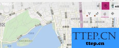
电脑win10自带的地图应用测量两个地点之间的距离的方法 电脑win10自带的地图应用怎么测量两个地点之间的距离 1、通过“开始”菜单,或让小娜帮忙,在 Windows 10 中启动“地图”应用,在地图上找到要测距的地方。如图为杭州西湖。

2、在地图窗口右上角的工具栏上,点击 Windows Ink 工具栏按钮,将弹出该工具栏。工具栏默认状态下,点击、按住并移动鼠标,将会移动地图;为了实现测距功能,需要点击工具栏最右侧的“触摸编写”按钮,转入绘制状态(该按钮由手形标志变为笔形标志)。
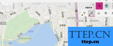
3、然后,点击工具栏上的“测量距离”按钮(尺形标志),进入测量距离功能状态。
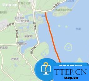
4、用鼠标在要测距的两个地点之间画线,线经过的地方,应该是适宜跑步或骑行的路径。

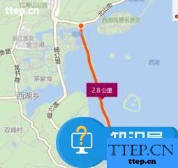
5、线画好后,释放鼠标,地图将进行计算,进而将线两端之间的距离显示在地图上。
6、如果发现画的线不准确,可以点击工具栏上的“橡皮擦”按钮,然后点击刚才画好的路线,即可让该路线消失;然后用上述办法,重新绘制路线即可。

2、在地图窗口右上角的工具栏上,点击 Windows Ink 工具栏按钮,将弹出该工具栏。工具栏默认状态下,点击、按住并移动鼠标,将会移动地图;为了实现测距功能,需要点击工具栏最右侧的“触摸编写”按钮,转入绘制状态(该按钮由手形标志变为笔形标志)。

3、然后,点击工具栏上的“测量距离”按钮(尺形标志),进入测量距离功能状态。

4、用鼠标在要测距的两个地点之间画线,线经过的地方,应该是适宜跑步或骑行的路径。

5、线画好后,释放鼠标,地图将进行计算,进而将线两端之间的距离显示在地图上。

6、如果发现画的线不准确,可以点击工具栏上的“橡皮擦”按钮,然后点击刚才画好的路线,即可让该路线消失;然后用上述办法,重新绘制路线即可。

- 最近发表
- 赞助商链接